
Walks around the route
Discover the diversity of Oberhausen on ten walks
Each tour starts and ends at a stop on the public transport route between the main train station and Sterkrade. The tours are between one and six kilometers long and can sometimes even be combined with one another, such as tour 2 and tour 3 or tour 5 and tour 6. You will also find the respective link to Komoot in the respective tour descriptions. We wish you a lot of fun!
Folding plan for walking routes
At a glance: all descriptions and some impressions of the walks

There are green oases to discover in many places in Oberhausen.
Home: Neumarkt stop
Objective: Neumarkt stop
Length: 5 km
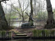
Highlights: Sterkrader Weiher + stone owl + wind garden + Sterkrader Hirsch + Sustmannshof + Reinersbach
Route:
An asphalt footpath leads from the Neumarkt stop to the Sterkrade park, which is 17 hectares in size, and on to the pond, home to many large and small water birds. A beautiful path goes around the pond. In the northern area, shortly after the small bridge, on the left is the stone owl by Karl Muschalek. It was installed in the schoolyard of the Tackenberg School in Sterkrade in 1964, but later had to be stored for many years until it was given its new location. Immediately behind the owl is the wind garden, which was built in 2014 as part of MULTI with young people and architecture students from all over the world.
From the eastern bank, just behind the striking climbing rock, the gaze falls on the sculpture of a life-size lying deer on the small island in the pond - the Sterkrader deer. The sculpture was made in 1904 and has long adorned a Sterkrad villa on Finanzstrasse. The stag later made its home in the Kaisergarten before returning to Sterkrade in 2004.
The path now leaves the bank and leads straight ahead and then at the end on the right to the Sterkrader Stadium and the Freiherr-vom-Stein-Gymnasium. You have reached Wilhelmstrasse, opposite a path leads across the Gymnasialplatz to Steinbrinkstrasse. After a few meters you reach Poststraße, opposite it goes on Augustastraße past the Sophie-Scholl-Gymnasium to Tirpitzstraße. Tirpitzstrasse leads to the left to Holtener Strasse.
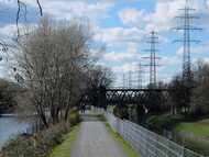
The footpath along the Reinersbach, which was freed from its concrete bed and renatured in 2009, begins on the other side of the street. Depending on the water level, it splashes idyllically through the meadows and is now inhabited by many microorganisms. The Sustmannshof can soon be seen on the left - the historic farm is one of the oldest farms in Sterkrade. The path continues along the course of the stream, later diagonally left over the motorway bridge and then in a large right-hand bend to Hamburger Strasse / Lübecker Strasse.
On the right it goes on over the north ramp. After crossing the autobahn again, a footpath leads to the right down to Kieler Strasse. Now it goes left to Sprockstrasse. After a few meters, a footpath on the right leads past the playground to the already familiar path on the Reinersbach. On the left it goes back to Holtener Straße. Cross the busy street on the left at the traffic lights and follow Eichelkampstraße straight ahead to Sterkrader Ring. The Eugen-zur-Nieden-Ring leads right to the destination, the Neumarkt stop.

The diversity of the city can be particularly well experienced on this tour.
Start: Sterkrade train station stop
Goal: Eisenheim stop
Length: 6 km
Highlights: romantic Elpenbach + St. Antony hut + St. Antony pond + Stemmersberg miners' settlement + Stanislaw Petrow memorial + Eisenheim settlement
Route:
Coming from Sterkrade train station, cross Arnold-Rademacher Platz on the left. The first thing you notice is a scaffolding with bells from the earlier carillon in the tower of the town center. At the beginning of the pedestrian zone, one of the few workers' memorials in the Ruhr area, the Eisenmann, also known as the tired Theodor or the hard-working Theodor, is hidden on the left. Now follow the Bahnhofstrasse, which is within walking distance, past the imposing city center building from 1931 on the left at the intersection of Bahnhofstrasse and Steinbrinkstrasse. Continue straight ahead, past the Technical Town Hall, Martha-Schneider-Bürger-Platz and left past the Sterkrader Tor health center to the large intersection. Cross this busy intersection twice so that the petrol station is on the left.
Follow Teutoburger Strasse under the bridge for a few meters to Anhalter Strasse. Turn right into the footpath. The beautifully landscaped path runs behind the Elly Heuss Knapp Foundation along the renatured Elpenbach to the excavation site at the St. Antony Hut. The archaeological park - the oldest industrial site in the Ruhr area - brings Revier's history to life. In the LVR-Industriemuseum St. Antony-Hütte, the former residential and office building from the time Gutehoffnungshütte was founded, you can find interesting background information on the development of the St. Antony-Hütte and the GHH.
A walk around the small Antony pond with its water fountain is compulsory and perhaps invites you to rest on one of the benches on the wooden plank path. Antoniestraße leads past the museum and then gently ascending to the right in the arch to Bockmühlenstraße. Follow Bockmühlenstraße left to Teutoburger Straße, straight ahead into Mergelstraße and immediately turn right and then left again into Hügelstraße. It runs on the edge of the listed miners' settlement Stemmersberg, first along the garden city Swiss houses from the years 1904-1906. A detour to the right into Aktienstraße shows the classic colony houses from the years 1900-1904 and leads directly to the welfare house built in 1912. Left over Gute Strasse and then left again over Ziegelstrasse, it goes back to Hügelstrasse.
Follow Ziegelstraße straight ahead, take the second access to the playground on the right and walk slightly downhill through Heidepark. A memorial here commemorates Stanislaw Petrov, the man who saved the world from a third world war in 1983. Few people know him and this memorial, which tells an exciting story. Opposite is a small arrangement under the motto “One World - One Garden” that was created as part of MULTI 2018.
Cross Vestische Straße and follow Erikastraße straight ahead. At the end turn left into Herbertstrasse, which shortly afterwards becomes Berliner Strasse. The Wesselkampstraße on the left leads to the Eisenheim stop. But before that, you can take a short tour of the beautiful Eisenheim workers' estate with its architecturally decorated houses, the pretty dormer windows, green doors and white window frames.

The Eisenheim settlement, built from 1846 onwards, is the oldest workers' settlement in the Ruhr area and has been a listed building since 1972. There is a lot to discover on this walk.
Start: Eisenheim stop
Goal: Eisenheim stop
Length: 1,5 km
Highlights: Sculptures and bird houses + historical settlement houses + talking streets + Eisenheim museum
Route:
Straight alleys and winding paths run through the settlement. The houses are lovingly decorated and decorated, tables, chairs, benches and toys in front of them indicate how lively the Eisenheim estate is. The tour starts on the left in Wesselkampstraße.
Not only are the oldest houses in the settlement located here, but the “talking streets” also begin here. In exposed places in Eisenheim there are a total of 70 boards that tell of life in and between the houses.
Turn right into Fuldastraße, then right into Werrastraße, one of the particularly beautiful streets in the settlement. Here, too, text panels report on life in the settlement and on the social history of the Ruhr area. The Eisenheim Museum is located on Werrastrasse, in the settlement's former wash house. It tells of the eventful history of the Eisenheim settlement, everyday life in the "colony" and the struggle of the Eisenheimers to keep their settlement. The exhibition shows "old treasures" such as furniture, everyday objects and pictures from the settlement. The largest and most colorful bird house in Eisenheim is also located here.
At the end of Werrastraße turn right into Eisenheimer Straße, then at the end turn left into Wesselkampstraße. Follow Berliner Straße to the left, at the end turn left through the small complex and then left again into Eisenheimer Straße. This is where the WDR documentary “Die Helden von Eisenheim” was filmed with pigeon father Manni Held, who touched the hearts of the audience with his caution towards the pigeons. The Eisenheim stop is already within sight.

Who knows, maybe this tour will reveal something about the German composer, playwright and theater director Richard Wagner.
Start: MAN TURBO stop
Goal: Stop at Olga-Park
Length: 2,5 km
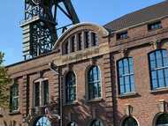
Highlights: beautiful tree-lined avenue + winding tower, Steigerhaus and gatehouse of the Osterfeld colliery
Route:
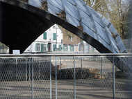
From Dorstener Straße, directly at the MAN TURBO stop, a pedestrian bridge leads over the A 516 and leads into Richard-Wagner-Allee. Whether the important artist ever walked lengthways here will remain a secret.
The avenue, designed as a footpath and bike path, runs more or less straight ahead under old trees to Fahnhorststraße. The footpath to the Eremitengarten leads right past the beverage market to Vestischen Straße. Follow this right to the Steigerhaus.
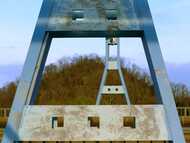
Under the scaffolding of the winding tower of the former Osterfeld colliery, shaft 1/2, you go straight past the listed Steigerhaus into Olga-Park. The area of the former Oberhausen State Horticultural Show (OLGA) offers a 25 hectare water playground, the “Schwarzes Tor” observation tower and many benches to rest. The 16 meter high observation tower offers a great all-round view of the city and the surrounding area. Take one of the paths to the right in the direction of the public transport route. Cross the bridge back to the Olga-Park stop.

Bridges play a special role on this short walk.
Start: Stop at Olga-Park
Goal: Stop at Olga-Park
Length: 2 km
Highlights: Blue Bridge + Millipede Bridge + Black Gate Lookout Tower
Route:
A footpath and bike path runs parallel to the public transport route in the direction of the Gasometer. After crossing the railway tracks, the A42 and the Emscher, a path turns left from the truss bridge. The nested bridges at this point are special. Follow the footpath in the direction of the Marina either at the same level on the dam or a little deeper directly on the canal bank.
After a short time there is a staircase to the bridge directly at the Millipede Bridge. The 230 meter long bridge got its name from its numerous metal supports. In 2001 she received the NRW Architecture Prize. At the top, walk right towards Osterfeld. At the end of the bridge, take the path down to the left along the old sewage treatment plant. It leads in a wide arc to Olga Park.
There is an entrance to the park immediately on the left. Stay left. The water playground is soon in sight on the right. You can now climb the “Black Gate” observation tower. Where the coking coal tower used to stand, this landmark rises today, which after 54 steps offers a great panoramic view over the site of the former state horticultural show and the city. Now it is only a few meters to the exit of the park. Cross the bridge back to the Olga-Park stop.

On this tour, a lot is reminiscent of the time of the Gutehoffnungshütte.
Start: Stop at Olga-Park
Goal: Stop at Olga-Park
Length: 3 km
Highlights: Black Gate observation tower + winding tower, Steigerhaus and gate house Zeche Osterfeld + memorial to the forced labor camp of the GHH
Route:
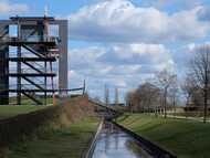
The pedestrian bridge at the Olga-Park stop leads directly to the park. The 25 hectare green area was built in 1999 on the site of the former Osterfeld colliery. Keep left at the fence, then take the entrance to the park on the right and climb the “Schwarzes Tor” observation tower via the ramp that leads over a small moat. This 16 meter high landmark rises where the coking coal tower used to be.
Follow one of the paths towards the winding tower. The headframe, the listed Steigerhaus and the two gatehouses belong to the former Osterfeld colliery, shaft 1/2. Between the gatehouses it goes to Vestischen Straße.
Take the footpath directly opposite and turn left at the first house to the Eremitenklause. On the masonry of Malzstraße there is a memorial for the former forced labor camp of the GHH, which was built by a group of pupils from the comprehensive school in Osterfeld. Go back to the Eremitenklause, then go left to the turning area and take the footpath to the left, past the kindergarten, which climbs up to Jacobi-Trasse after a few meters behind the kindergarten. This former freight railway line ran between the Osterfeld colliery and coking plant and the Haniel dump. Walk left on the Trassenweg to the Olga-Park stop. The path offers a beautiful view of the former colliery area and the changes that have taken place in the meantime.

With the Kaisergarten and the Grafenbusch settlement, there are two real treasures to be discovered.
Start: Stop at Olga-Park
Goal: Stop at Olga-Park or stop at Neue Mitte
Length: 5,5 km
Highlights: Bridge Slinky Springs to Fame + Kaisergarten + relaxation loungers at the Kana + animal enclosure + Kaiserkrone + classical palace complex + Grafenbusch settlement + gasometer
Route:
A footpath and bike path with a view of the gasometer runs parallel to the public transport route. After crossing the railway tracks, the A42 and the Emscher, a path turns left from the half-timbered bridge to the banks of the Rhine-Herne Canal. The nested bridges at this point are unparalleled. Right now it goes in the direction of the Gasometer and Oberhausen Castle.
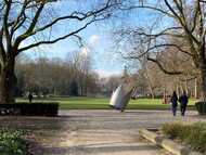
The 405 meter long, accessible bridge sculpture Slinky Springs to Fame by the artist Tobias Rehberger leads spectacularly over the canal directly into the Kaisergarten. It is the oldest and certainly the most beautiful public green space in Oberhausen. It goes back to the hunting woods of Count Westerholt-Gysenberg. Over a period of around 40 years, the city of Oberhausen developed the Kaisergarten from the former floodplain forest at the castle.
The Rehberger Bridge with its 496 aluminum arches offers a beautiful view of the Gasometer and the Rhine-Herne Canal. Keep right at the foot of the bridge. Now either take the path straight through the animal enclosure and leave it at the opposite end. Or go right to the canal bank and choose the bank path on the left. Then take the first path on the left and go straight on and later “conquer” the small viewing plateau via a few steps. The view over the park and the pond can be enjoyed on benches.
Go down a few steps on the left to the lake and halfway around it counterclockwise. On the paved north-east bank, choose one of the paths in the direction of the Kaiserkrone. Go straight ahead after the Krone, then take the path to the left towards Schloss Oberhausen. It was built at the beginning of the 19th century and acquired by the city of Oberhausen in 1912.
The beautiful inner courtyard with a well-stocked shop, the free-access memorial hall in the side wing of the classical palace complex, in which the history of Oberhausen at the time of the Second World War is taken up, and of course the LUDWIGGALERIE offer a great backdrop and invite you to linger. In front of the memorial hall there is a basalt sculpture by Willi Meller, “The Mourners”. Leave the inner courtyard in the direction of Konrad-Adenauer-Allee, but not without first having a quick look at the 6-meter-high sculpture “Red Heels” by Pop Art artist Heiner Meyer.
On the opposite side of the street, a footpath leads to the Grafenbusch settlement directly at the bus stop. The unique estate was built between 1910 and 1923 according to plans by the Berlin architect Bruno Möhring for executives at Gutehoffnungshütte. The upper-class villas were built in the English country house style and are partly in park-like gardens. Part of the settlement is a listed building.
Follow the street Am Grafenbusch diagonally to the left, then the first street on the right and at the end on the left, past the climbing garden, walk to the gasometer. The gigantic former gas storage facility with its 117 meters offers a spectacular setting for cultural experiences and great exhibitions. To the right at the foot of the gasometer, a narrow path leads to the canal. Go under the bridge construction on the right on the canal bank path, then take the steps up to the bridge on the right. On the right, the Trassenweg leads back to the Olga-Park stop; the Neue Mitte stop is also not far away on the left. If the path at the Gasometer is closed, an asphalt road runs 100 meters further to the right parallel to the sports facility of the Oberhausen tennis and hockey club and also leads to the Trassenweg.

The classic among walks combines the bustle of the promenade and marina with the tranquility of the wooded garden.
Start: Stop at Neue Mitte
Goal: Stop at Olga-Park
Length: 6 km
Highlights: Marina + twin arches O + woody garden + RVR information center Haus Ripshorst + sorcerer's apprentice
Route:
The walk leads first over the promenade and then on to the marina. Up to 60 sports boats swing here and create a maritime atmosphere. Steps lead to the harbor basin and a little later up to the AQUAPARK. To the right of the leisure pool, the path runs in the direction of Osterfelder Straße. On the left is the twin arch O, a steel sculpture by the sculptor Rolf Nolden.
To cross Osterfelder Straße safely, turn left and then at the traffic lights across the busy street. This is where the entrance to the Ripshorst wood garden is located. A promenade meanders through the band of trees and shows the development of vegetation over 60 million years. The individual areas are signposted and numerous information boards provide information on the respective type of planting. It is particularly beautiful here in autumn when the maple trees convey a feeling of Indian summer.
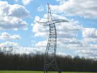
House Ripshorst is soon reached - as the small bridge is closed, the path leads right over Ripshorster Straße and then left over the parking lot to the former historic Ripshorst estate, which is now home to the RVR visitor center. The permanent exhibition on the Emscher Landscape Park provides multimedia and interactive information about the tourist highlights of the 450 square kilometer regional park. The path now leads between the buildings to the banks of the Rhine-Herne Canal. The sorcerer's apprentice, the dancing power pole, can be seen particularly well from here. The 35-meter-high and 10-ton sculpture by the Berlin artist collective Inges Idee “dances” on the meadow.
Follow the path to the left - it ends at the marina. Via Heinz-Schleußer-Strasse, turn right towards SEALIFE. To the left of the building, a footpath or bike path leads slightly upwards. Before the path leads right to the bridge, the walk continues diagonally to the left. The path now runs behind the Centro amusement park and joins a footpath parallel to the public transport route. Shortly afterwards, you will reach the Neue Mitte stop on the left, and the Olga-Park stop on the right.

The Knappenhalde, popularly known as Monte Schlacko, rises 102 meters into the air. It is the highest point in Oberhausen and offers a wide view of the old and the new center.
Start: Fire station stop
Goal: Lipperfeld stop
Length: 4,5 km
Highlights: Art on the Knappenhalde + observation tower + Henkelmann bridge
Route:
A footpath begins directly at the elevator from bus platform 2 (in the direction of the main train station), which initially leads along the fire brigade's sports field and later in a wide arc around the fire brigade and technical relief organization and on through the Brückorpark.
After crossing under the public transport route, follow the street Am Damm on the right, then turn left into Winkelriedstrasse. At the end of the street, continue to the right on Wilhelm-Tell-Straße to Brückorstraße, then turn left and shortly afterwards left again into Lipperstraße. Opposite house number 49, the ascent to the Knappenhalde begins.
The spiral-shaped path is provided in several places with mosaics made of paving stones, a total work of art by Werner Philipp Klunk from Oberhausen. Straight ahead, gently rising, follow the wide path to the summit, which is crowned by an observation tower. Not only from here, depending on the season and the foliage of the trees, there is an interesting view of the city. In return, it can be accepted that the Knappenhalde looks a bit “untidy” due to transverse trees, dead wood and one or the other garden waste at the foot of the heap.
When descending, either take the same path or take the first option on the right to choose an alternative way to descend. Be careful, in wet weather it can get slippery here, the path is relatively steep in the lower part. The path also ends again at Lipperstrasse.
Return the same way via Lipperstraße, right Brückorstraße, right Wilhelm-Tell-Straße, left Winkelriedstraße, left Am Damm. A combined footpath and bike path begins at the intersection, which first runs under the public transport route and then on the right parallel to the route and then continues over the Henkelmann Bridge. It got its name, so it is passed down, because the children and women used to let their husbands take the warm meal in men with handles from the bridge by strings. At the end of the bridge the Lipperfeld stop is reached.
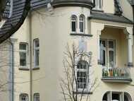

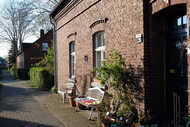
The theater district is home to art, culture and carnival (!). It is one of the most important historical bourgeois residential quarters in the Ruhr area from the early days. Here the beauty lies above all in the details: bay windows and balconies, gables and moldings and ornaments again and again.
Start: Central station stop
Goal: Central station stop
Length: 2,5 km
Highlights: Grillopark + Villa Concordia + Oli's Büdchen + Ebertbad + Carnival Museum + golden balconies + Adamas + capital of the old town hall
Route:
From the main station go straight past the tax office to the small green area in front of the Luise-Albertz-Halle. The steel snail, a sculpture by the artist Horst Wolfframm, greets you here.
We continue to the opposite town hall, which was built in 1930 according to plans by the builders Freitag and Jüngerich and is one of the most important expressionist buildings in Germany. Cross the small Grillopark on the left, keep left briefly and turn into Grillostrasse. On the left is the Villa Concordia, an old director's villa, which was built in 1897 in a mix of late Renaissance and neo-baroque styles. The former private garden from the Wilhelminian era, today's Königshütter Park, extends directly behind the villa.
Go straight on Grillostraße or the path in the park that runs parallel to the street until you reach Ebertstraße. In Grillostraße there are beautiful villas from the turn of the century, some richly decorated with ornaments or pictures. Not far away: Oli's Büdchen, the most famous drinking hall in town. The Grillostraße leads past Ebertplatz with the old bathing establishment Ebertbad. It was opened in 1895 as one of the first public bathing establishments. At the end on the right in front of the daycare center, a footpath turns off along John-Lennon-Platz to Sedanstrasse. Keep right.
The town theater, also designed by Ludwig Freitag, follows houses with beautiful facades. The Carnival Museum is located across the street in the old bunker.
Follow Sedanstrasse on the other side of Ebertstrasse, turn left into Freiherr-vom-Stein-Strasse and then right into Elsa-Brändström-Strasse. Probably the only golden balconies in Oberhausen are located here. Right in front of the town hall is Adams, a 7 meter high work of art made of aluminum, stainless steel and acrylic by the Oberhausen artist Günter A. Steinmann. Next to it and easily overlooked, a Corinthian capital is reminiscent of the old town hall, which was destroyed in the war in 1942.
Cross Schwartzstraße and take the Henri-Dunant- (Fuß) -Weg opposite to Danziger Straße, then turn right, past the Luise-Albertz-Halle, towards the train station. On the left there are two more architectural highlights: The former employment office, unfortunately no longer in good condition, is an interesting brick complex based on a design by Ludwig Freitag. A few meters away there is a large, neo-Gothic brick building, today's Adolf-Feld-Schule, with a beautiful facade.

Tour 1: Sustmannshof

Tour 1: Reinersbach

Tour 1: Sterkrad's Owl

Tour 1: Little paradises

Tour 1: Bridge over the A3

Tour 2: Antonie Park

Tour 3: Talking streets

Tour 3: feeding place

Tour 4: Bridge to Olga Park

Tour 5: Dewfoot Bridge

Tour 5: Old Osterfeld sewage treatment plant

Tour 5: Always under power

Tour 5: Black Gate observation tower

Tour 5: Evening mood at the Black Gate

Tour 6: Spring in Olga Park

Tour 6: Memorial

Tour 8: twin arch O

Tour 8: Ripshorster Bridge

Tour 8: Blossom splendor at Haus Ripshorst

Tour 8: Busy bees at Haus Ripshorst

Tour 8: The sorcerer's apprentice dances

Tour 9: Lipperfeld stop

Tour 9: View of Lipperstrasse

Tour 10: Adamas

Tour 10: Oberhausen town hall

Tour 10: House entrance

Tour 10: Carnival Museum

Tour 10: Greetings from the mining industry